


7:45PM, Sunday, July 13: Severe Thunderstorm Watch remains in effect for southern Quebec.
Storms are moving off to the south and east of Montreal, and the water is receding quickly on area highways. A few more cells are possible before midnight. There are still some road closures around Highway 13. Many highways were flooded during the height of the storm, as well as some homes and businesses, especially from Saint Laurent into the north end of the Island of Montreal. Many roads on the West Island also has significant water accumulations.
Previous Post: Flash Flooding occurring on several highways in Montreal.
Strong thunderstorms will impact the island of Montreal for the rest of the afternoon and evening, with very heavy rain and dangerous lightning. Some flooding is possible.�����Ƶ
A frontal boundary is sliding into a very warm and humid air mass located across southern Quebec. The front has been triggering strong, very moist thunderstorms that have been training across the Montreal region since about 2pm. The result has been over 50mm of rain in several locations, including 54.2mm here on Ile Perrot.

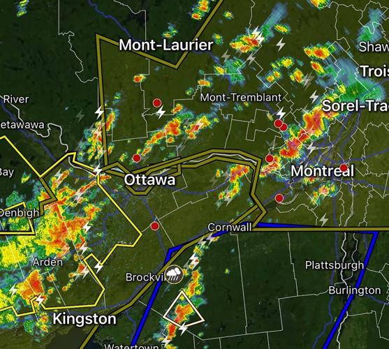
Radar image showing multiple rounds of thunderstorms over the Montreal region Sunday afternoon. Three separate cells have dropped more than 50mm (2 inches) of rain on Ile Perrot since 2pm.
More storms are developing to the west and southwest of Montreal. Heavy rain is producing some localized flooding as well as ponding of water on roadways. The lightning has been intense.
Over 35,000 Hydro-Quebec customers are without power as of 4pm, half of those in are located in Montreal and the�����ƵMontérégie. More thunderstorms are likely through the evening hours, so the threat for flooding remains.

Heavy rain from strong thunderstorms has produced flash flooding in several locations across the region. The Decarie near Royalmount is reporting flooding as is Highway 40 west at Highway 13 and Highway 40 east near Cote-Vertu.
The air mass will remain very warm and humid for most of the upcoming week, with the risk for showers and thunderstorms daily through Thursday. Highs will be over 30C (86F), with lows near 21C (70F).

Commented